Was I abducted by aliens? Or am I just full of $#!+?

You’re not going to believe what happened to us. Last night, we were sleeping in our trailer in Albuquerque, NM, minding our own business. Then, towards morning, this bright orange light came up over the horizon. I remember later being transported in some kind of metal craft. Next thing I know, it’s four hours later and I’m standing hundreds of miles from where I was the night before, near a place where a UFO was previously reported!.

I want to emphasize here that I’m not just making this up – everything I said in that paragraph is completely true…

Yes, today we found ourselves mysteriously transported to the “Dairy Capital of the Southwest”.

A vending machine in Roswell, New Mexico, showing a space-alien drinking Coca-ColaYes, the one from the Futurama episode. Though they didn’t talk much about cows in that one.

Besides, for some reason I get the impression that milk isn’t necessarily the most popular beverage here. Indeed, I get the impression that the dairy products around here are more industrial in nature. Heck, if you ask Google Maps for “cheese in Roswell, NM”, all that comes up is mass-market manufacturer “Leprino Foods”. What, not even any stores selling “moon cheese” to cash in on the whole UFO/Space-alien thing? Perhaps they only keep the cattle around to give the space-aliens something to practice their probing on.

With no prospects for sampling the apparently nonexistent famous regional cheeses, there was only one thing left to do. Yes, I admit it, we went to the UFO Museum (“and Research Center”).

I feel compelled to give them high praise on at least one point: they have signs which declare cameras and other recording gear to be explicitly permitted. A refreshing change after visiting the otherwise impressive Museum of Wildlife Art a few weeks back in Jackson, WY, which loudly forbade “cameras and cellphones”. Because, heaven forbid a blurry image taken by a cellphone of a painting which escaped copyright several centuries ago be seen on the internet without paying an additional fee. This would certainly cause the museum to collapse in bankruptcy within days.

But I digress…

Built into what appears to have once been an old single-screen movie theater building, it was well worth some touristy amusement. Ironically, I didn’t see a whole lot that I actually wanted to take pictures of. I did derive a certain amount of amusement from taking a picture of the framed photograph they had of a sign from Area 51 saying “no photography in this area”…but, appropriately enough, it came out too blurry to be verifiable. I suspect interference to my digital camera due CIA mind-control rays reflected from my Aluminum Foil Deflector Beanie.

It was actually kind of like a text-heavy art museum. Virtually all of the displays were framed photographs or copies of documents, though they do have, for example, what is apparently an authentic 1950’s USAF falling-from-great-heights test dummy on loan from somewhere. They still have lots of open space left, which is probably why they went ahead and filled one section with someone’s exhaustive and yet still laughable display on “crop circles”. Oddly enough, the portions dedicated to the actual “Roswell incident” aren’t bad. As you can imagine, I thought the presentation was still a bit overly credulous, but it was nowhere near what I had expected, which was a “balanced” presentation as favored by our mainstream media – that is, something along the lines of “could it be a crashed alien spaceship covered up by a secret government conspiracy, or merely this ridiculous story about a weather balloon?”. Instead, it looks like they’ve just collected as much as they could in the way of newspaper clippings, photographs, affidavits, reports, hypotheses (including, yes, the whacky ones) and so forth, and tried to present them all.

There was one really spooky thing I saw in there though:
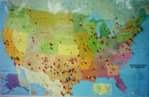
This map near the entrance is for visitors to mark where they’ve come from. I immediately noticed the odd clustering that seems to run from New Mexico, curving up through Texas, and up to Illinois. I mentioned this to my Minister of Domestic Affairs, who happens to be a geophysicist with a Ph.D. “Tornado Alley“, she immediately recognized and pointed out to me.

You all see, dear readers, where I’m going with this, don’t you? It’s so obvious:

  • Tornadoes love trailer parks, right?
  • What’s the stereotype of the kind of person who sees UFO’s or is abducted by aliens? The kind of people who are assumed to live in trailer parks, right?
  • All those blurry photos of UFO’s come from devices for recording visual images, like, say, camcorders. Right?
  • And, finally, it is a scientifically documented fact[1] that the occurence of tornadoes can be correlated to the combination of camcorder sales and trailer park presence.
  • THEREFORE

  • This proves space-aliens cause tornadoes, perhaps to flush potential abductees out of hiding.

I eagerly await further research on my groundbreaking hypothesis.

Meanwhile, what’s a museum without a gift-shop, where fine and tasteful products may be purchased?

space-alien-head golf balls
Uh…or maybe not.

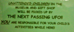
Unattended Children in the Museum and Gift Shop will be picked up by THE NEXT PASSING UFO!! YOU are responsible for your child's activity while here!

On a final note, I must say I approve of their unattended-child policy, though I have to admit I like the “free puppy and an espresso” one better.

[1] Wu F:”TORNADOES AND TRAILER PARKS: A STATISTICAL CORRELATION” Ann. Imp. Res.; Jul/Aug 1995 (1:4); pp 26-27 (also available online here).

Gather and harken unto my tale of woe!

Well, this roadtrip has been rather difficult so far. Not necessarily bad, but definitely difficult.

It was about a week before the weather would let up enough for us to even escape our home state. I came down with a cold as we were leaving. The campground we were originally going to be staying at on the second night was mysteriously closed for the season despite supposedly being open year-round. Panoramio appears to have forgotten that I exist and won’t let me login to upload more to my photos (and I’ve not yet heard back from the email contacts there about getting back in). And then on the third night, neither of the truckstops next to our campground had sour cream. And the following morning, after stopping briefly to pick up some food for breakfast, the truck sputtered and died on the way up the onramp to continue the trip. And then we had some stress and confusion getting things worked out initially with the RV’ers organization to get towed to a repair shop and a campground. And then my wife has apparently picked up the cold that I’m getting over now. And then someone took a doody in my sandbox…oh, wait. That was just a “song” on one of my CD’s. Never mind.

On the other hand, we did manage to finally escape our home state, we did find a replacement campground for the second night, we did get everything worked out okay, and our truck’s problem turned out to be a relatively minor issue with the distributor though it evidently took a fair amount of labor to extract, fix, reassemble, and reinstall it, and we should be able to get back on the road in the morning. So, enough whining from me for now.

Meanwhile, I’ve thought about my “geotagging arbitrary files” issue a bit more. At this point I’m favoring the “geostrings” approach, split into what I’m calling “Where, When, and Whither” fields, which is to say, a field containing location (latitude, longitude, elevation), a field containing time-related information (timestamp, track-id), and a field containing direction (heading and angle) information. I’ve actually started putting geostrings in this form into some of the pictures I’ve been taking, just to get a feel for how easy or hard they are to work with. An example containing all information including the optinal stuff would look like this:
geostr:35.068531033,-106.5019369,1716.0905m:20080104T122418-06,track01:60,20:geostr

The “where” field is latitude, longitude, and elevation, separated by commas. The “when” is the ISO8601 standard simplified timestamp and a track ID, and the “whither” indicates a heading of 60° and an upward angle of 20°. The colon-separated fields and the comma-separated data within each field are in order from (as I perceive it) most important to least important. Aside from the latitude and longitude, and the “geostr” markers on either side, everything is optional.

Comments?

Linking this more-relevant latter portion of the post to the whining at the beginning is the fact that the cold I’m now getting over has messed up my voice. I did bring microphones and both my computer and some cheap portable recording gadgets, so at some point along the way I still want to do at least one short audio recording, geotagged and including an embedded image to go with it. I just need to wait for my voice to properly return (and to spot something about which I feel an urge to inflict people with my blabbering.)

I can has graduation?

The last undergraduate final is over.

Everything it taken care of save for one overdue library book, which I intend to take care of tomorrow.

All the other fees are paid. All the paperwork is done. I’m pretty sure I got well above the F– that was the minimum I needed on the Philosophy final to achieve the minimum passing grade. In fact, my only current stress about my grades is whether or not I managed to end out my last undergraduate semester with a 4.0 or not.

I FEEL BETTER THAN JAMES BROWN! WHEEEEEEEEEEEEEEEE!!!!!!!!!!!!!!!!!!!!!!!!!!

Let the wild, uncontrollable drunken orgiastic celebration begin!

After my nap

I’m having too much fun with this.

I finally managed to get Hugin to work, as you can see from the picture of the Dead Fish Museum above.

Okay, it’s the visitor’s center at the Fossil Butte National Monument, but it really is a museum of dead fish. And other fossils. If you click the image to get to the Panoramio page, you can even see where it is on the map: in fact if you zoom in, the building itself is visible in the aerial photo imagery.

Between digiKam’s ability to handle geocorrelation with tracks from my GPS, Panoramio’s support for geolocation and mapping (and connection to Google Earth…), playing with High Dynamic Range digital photography, and now panoramas, I’m beginning to develop an increased urge to travel around and take pictures again…

Nerd Photography in the Big Room

Readers may have noticed by now that I have a cheap but serviceable digital camera that I’ve been using to take pictures which occasionally show up here on the blog. (Hey, there’s another thing that the External Deliverer, in Its benevolence, might bring me: a nicer digital camera.)

I’ve been playing with geolocation for a while now. Just recently, I started also doing some crude playing with High Dynamic Range digital photography. It’s obviously going to take me some work to get it figured out and get better results, but what I’m getting so far doesn’t look too bad, at least in my own opinion. Kind of surreal, like Mars Rover pictures…

I’ve discovered that my Handy-Dandy Linux box has access to a couple of tools that make these easy.

I noticed a few days ago that digiKam is actually able to read .gpx format files downloaded from my GPS and then correlate the track from the GPS with the timestamps on the photos automatically, so in what little spare time I have I’ve been going back through my archives of GPS tracks and timestamped photos and trying to find as many to correlate as I can. I managed to get geolocation tagged into pictures from as long ago as three years or so. I also tagged this more recent one. I saw this place half a decade ago and had been wondering if it was still there. Last week we finally had a chance to visit and sure enough, it was there. If you were wondering where one could go to learn to do the Squirrel Dance, here it is.

Landscape and Sign:Don't Trespass on the 'I'

Today after classes I trudged up to the top of the hill at one corner of the campus with my trusty GPS in hand and took a few pictures, as you can tell. Since Google Earth seems to get most of it’s photos from Panoramio, I’ve started uploading them there. I may also get around to uploading them to flickr one of these days, too. I kind of need some pleasant distraction – I’m starting to hit the “Am I there yet???” phase of the semester. Just another week-and-a-half of classes, then finals, then I’m finally done. At least with the undergraduate stuff.

If you’re bored, there are a couple of additional pictures on the Panoramio site, here. You can also get the ICBM address there, and a .kml file for Google Earth so my pictures will pop up if you happen to run past an area where one of them is while you’re browsing the globe.

Superman is Homeless!

Two weeks of midterms, and now it’s finally Thanksgiving Break week.

In honor of this celebration of my second most favorite deadly sin, I was going to do a food post, but I’ll save that for later.

Instead, I want to share a shocking and surprising fact that I’ve discovered: People are Stupid.

Actually, that’s not true, it’s really more like “People are Lazy, and Thinking is Work”, but “people are stupid” is easier to say.

Today’s illustration of this principle includes a visit to the former town of “Metropolis, Nevada” (link goes to Google Maps image, centered in front of the hotel. Should pop up in a new window.).

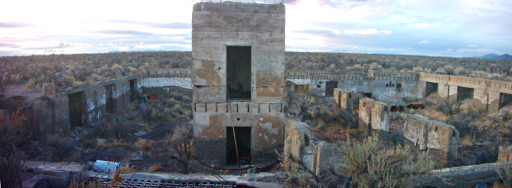
Composite image of the ruins of the Metropolis Hotel

Yes, evidently a bunch of developers from New York thought it’d be a great idea to build a big city in the barren deserts of Northeastern Nevada. This is where the “stupid” comes in.

Check out that map, zoom out and look around. What do you see? Yes, that’s right: sand, sagebrush, and dead grass.

There’s something downright appalling about the way people in the Western United States (where I’ve lived, in various places, for the last couple of decades) romanticize living in the middle of a desert, while at the same time trying desperately to pretend that they’re NOT living in a desert.

Here’s the story of Metropolis, as I understand it, in short form: Bunch of New York developers decide to build a big city for Mormon settlers. In order to pretend they’re not living in a desert, they figure they’ll just dam a spot on the small river to the northeast somewhere so that can stop enough water to keep themselves running.

Now, plunking down in the middle of the desert and pretending there’s nothing odd about building a large water-demanding city in it is a time-honored tradition of the American West, so why didn’t it work here?

Apparently, it’s because somewhere in the Lovelock, Nevada area a bunch of people said “Hey! We were here using that river’s water to pretend we’re not living in a desert first, so you can’t take it away from us by damming the river up there! So there!”. And the courts agreed.

You might think the teachers at the local school would be educated enough to know that “desert” means “lack of water”. I went over to ask about this, but…:

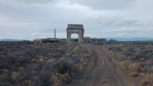
The ruins that once was the Metropolis, NV high school.

I guess school’s out for the moment. I wonder what their sports mascot was. “The Metropolis Dustbunnies?”

I was reminded of all of this by a recent story that was going around about some developer who thinks it’d be a great idea to build a 100,000,000 gallon-per-year water park in Mesa, Arizona. Which, for those unfamiliar with the area, is a desert just like Metropolis, only substantially hotter.

He’s not the first one though. Palmdale, California – out on the edge of the ‘Los Angeles area’ of California, appears to have the aptly-named DryTown Water Park. Palmdale is in the area of the Mojave desert. I have no idea how much water it uses up. I’m certain there are numerous others in the Los Angeles area alone.

It’s something to think about if you find yourself wondering why the Los Angeles area continually induces the shunting of water from other parts of the country to itself, like a cancerous tumor inducing blood-vessels to form in order to feed its own growth.

It’s probably obvious that I’m tired of living in deserts…