Another cheatin’ “Open Thread” and random stuff

No single topics to dominate a post today. I’m in a hurry (as usual lately) and have very little time. Tomorrow morning I’m back on the 1600-mile route back to Southeast Texas, hopefully to sign the closing paperwork on the house we’re trying to buy.

My Mountain Dew® Wine appears to be still sitting there after several hours. Either the benzoic acid is still inhibiting the fermentation (in which case it’ll go REALLY slowly) or the yeast is just in shock or something. We’ll see how it looks in the morning. I’ll leave it for a week or so anyway to see how it does. Meanwhile I’ll refrigerate the other batch of yeast culture until I get back. If I have to develop my own strain of “Mountain Dew Yeast” I will, dagnabbit!

I did get a chance to go for a quick walk in the Big Room on the way back from some errands yesterday, so it gives me an excuse to play with the wordpress map plugin again (RSS feed readers: the map doesn’t get inserted there. Please check out the interactive map at the blog’s website here.) Comments on the map (or anything else, really – I DID say “Open Thread” after all) are encouraged – what do you think? I’d like to do some audio content for points on a map at some point, too. Maybe some video.

Lava Rock Walk [height=560;width=560]

If anyone’s bored enough to want to see how I get from Southeast Idaho to Southeast Texas, I can post a map of that tomorrow, too…

I finally got to Bristol Brewing Company…

Signage in front of the Bristol Brewing CompanyAfter spotting the company’s mention in Jeff Sparrow’s “Wildbrews“, I’ve been wanting to visit Bristol Brewing Company, particularly since they may be the only such brewery using local yeasts and bacteria that they isolated themselves from their local environment.

Since we’re moving from Southeastern Idaho to Southeastern Texas, I’ve been going back and forth between the two location. It just so happens that along with New Belgium Brewing Company, Bristol Brewing is actually right along a convenient route between the two locations. (Let’s see if I can figure out how to work the Google Maps plugin):

How’s that look? How does it work? (Those of you reading this on the RSS feed: The interactive map only appears on the website, it would seem. Please check it out here.) I made the KML file myself…

Bristol Brewing is a cozy little brewpub, and the people there are encouragingly helpful. They were in the middle of bottling, so there were no tours. Also, there were not currently any of the skull-‘n-bones beers available. However, I did get an educational series of tastes of their current brews on tap (thank you to the employee I spent most of the time talking to whose name I’ve embarrassingly forgotten, but who I believe was Tad Davis judging from the photos on the web site). I also lucked out and their microbiologist, Ken Andrews, happened to be there. I asked about their native Colorado brewing flora. Turns out Bristol Brewing isn’t quite as bold as I originally thought. They’re still doing their primary fermentation with “normal” brewing yeasts. What they’ve done is inoculated some wine barrels with the locally-isolated yeasts and bacteria, and they use the barrels for a secondary fermentation and aging instead. Much safer if you have to worry about having a drinkable product at the end, and of course it makes me feel like more of a crazed rebel for wanting to isolate my own local bugs for the main fermentation. So, a great visit overall.

Incidentally, it seems they’ll be tapping a new Skull-‘n-Bones brew in a couple of weeks, at 5pm on Tuesday, May 27th (2008). It sounds like they’ll probably have some available for a few days before it all disappears, so I’m hoping my return to Texas can be timed such that I can swing by and at least get a taste.

Where Was I?: “I’m going to have a place like this someday…”

Brewery building for the New Belgium Brewing Company in Fort Collins, CO

Quality Assurance lab at New Belgium Brewing Company, as seen through the 'employees only' door.Incidentally, did you know it’s a long way from southeastern Idaho to southeastern Texas? I made the drive last week, and I’ll be making the drive back as soon as I can get some things FINALLY done around here. On the upside, it’s kind of a fun, if long, drive other than Wyoming’s tendency towards having ridiculously high winds and roads paved with what appears to be a mixture of wet ice and motor oil. I made it down here though, but I’ve already been delayed about a week due to some issues getting inspection arranged on the home we’re trying to buy out here. But you didn’t come here to read me whining about that, did you?

On the way down, I did manage to stop at one of the two Colorado breweries mentioned in the “Wildbrews” book. New Belgium Brewing Company just happened to be only a couple of blocks away from my route through Fort Collins, so I took the opportunity to stop by and check them out.

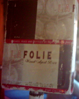
If you’re familiar with them at all, it’s probably for their “Fat Tire” amber ale which I have seen in stores around the country, but I didn’t care about that. What I cared about is that they actually let their microbiologist (and, it turns out, their other employees too) play, and they have experimental “sour” beers in the same general style as Belgian lambics. Pictured at left is their famous one – “La Folie” (“the folly”). Well, the label on the tap for it, anyway. I’m not certain if cultures other than the standard canned strains of Saccharomyces cerevisiae are used in the initial ferment, but they then move the brew over to barrels that were previously used to age wine, and which no doubt contain a variety of traces of live lactic acid bacteria, other yeasts, and the like (their website also suggests they directly inoculate the beer with lactic acid bacteria as well). The brew sits in the barrel for up to 3 years. The result is nicely carbonated, and tastes almost sweet to me due to the pleasant tartness of the lactic acid. This particular brew is mentioned in the book. Seeing my obvious enthusiasm for the style, I was also allowed to taste a more recent concoction. “Eric’s Ale” was a lighter sour brew made with peaches which I absolutely loved. I really wish they’d had it in bottles for me to buy, but neither it nor “La Folie” were available in portable form, as far as I could tell. Guess I’ll just have to make my own. Once I finally manage to sit in one place long enough to try, dangit.

It was the Belgian Lambic-style ales that convinced me that I really do like beer after all, so long as it isn’t mass-market commercial swill (“Bladderwash”, as Leon Kania, author of “The Alaskan Bootlegger’s Bible” calls it) nor too strongly hops-flavored.

I did taste their “1554” ale – a “black ale” style that they were able to date back to at least 1554 while doing research on the style in Belgium, and several others whose names I don’t recall at the moment. One brew whose name I don’t remember was spiced with Yerba Mate – a caffeine-containing South American herb also found in Celestial Seasoning’s “Morning Thunder tea. (Ethanol is nice and all, but methylxanthines are my favorite…).

And, no, I didn’t forget their names because of drunkenness. When I say “taste” I mean I had a sip or two of each variety I sampled. They had these nifty little glasses like miniature brandy snifters for tasting. I’ll need to get me a set of those one of these days.

An unrelated bit of spiffiness about the brewery is that they seem to run the place as “green” as possible. They even go so far as to subject their brewing wastes to bacterial fermentation to produce methane, which they use to heat their water. How cool is that?

On a final, still unrelated note: there’s evidently been a fad of people selling things on eBay that have shiny surfaces, such as metal teapots. The trick is to take the picture of the item while naked, and standing such that one’s reflection is just visible in the picture of the item that appears on eBay. You know those classical shiny aluminum “Airstream” camping trailers? They had one out in the parking lot.

Photograph of New Belgium Brewing Company's 'Airstream' trailer.

Wait…I don’t see myself in that at all. Dagnabbit, standing in that freezing cold wind with everyone staring at me was a waste of time, wasn’t it…

The other “wild brew” place in Colorado is the Bristol Brewing Company in Colorado Springs. Unfortunately, the only indication I can find of their “wild” brews is a “sour beers” class they did as part of their recent “beer college” series, and a “Skull ‘n Bones” (evidently what they were calling their sour-beer series) T-shirt. As there is also no mention of brewery tours, I did send an email off to the person who appeared to be the contact for such questions, but I’ve yet to hear back. I’d love to stop by on the trip back, but the route will add a couple of hours to the overall trip. This would be well worth it if they’re doing tours, or still doing “sour” beers, or if I could even spend a few minutes chatting with their microbiologist. If not, though, I’ll just have to get on with working on it all myself.

Oh, yes, and the place in Austin that I previously mentioned was called “The Bitter End”…and it ended. Apparently a fire destroyed part of it, and now its being demolished to make way for a massive chain-hotel building. How sad.

The tasting counter and beer cooler inside the New Belgium brewery.

I should be getting more done…

Im Name des Nudelmonster! It’s been over a week since my last post!

“Someone” seems to have located a replacement original disk of a game I had many years ago (but lost when I loaned it to someone) and bought it for me. Now, in addition to a variety of issues I need to deal with related to moving over the next few months, I have this delightfully surreal old computer game beckoning at me. ARGH! MAKE IT STOP!

Meanwhile, I’ve been trying to put together topics for next week’s “Just Science 2008”. We’ll find out who, besides me, is interested in fermentation once it starts. I think I’ll have to start off the series with a post on evolution, however, since it really does play a fundamental role when it comes to yeast culture. I also think I may be able to work JellO® into at least one of the posts, too…

Internet connection will be spotty the rest of this week as we travel towards the area that is to be our New Home, but I should have posts assembled in time for next week.

If I get a chance, there will hopefully be at least one more Geostrings post, possibly with a sample mp3 and/or Ogg/Vorbis audio file.

My “geostrings” project, and coming attractions.

I have set up a more permanent “page” for my little project to come up with a way to embed geotags in things like mp3, Ogg/Vorbis, video files, text documents, image formats besides jpeg and geotiff, and so forth. I’ve got a definition of the format and a basic description of the parsing algorithm for it up there. Embedding and decoding examples and so forth will follow soon, though I’m hoping for some comments before I get too deep into assuming I’ve got the format finalized.

Meanwhile, I’ve signed on for this year’s “Just Science” week, So I’ve got to get together at least five consecutive days worth of science posts to go up between February 4th and 8th. Fortunately, I think I can fill most if not all of it with the brewing science (and yeast culture in particular) stuff I’ve been researching. I’d still like to get my hands on at least one more paper which isn’t readily available to me (Gasent-Ramírez JM, Castrejón F, Querol A, Ramón D, Benítez T.: “Genomic stability of Saccharomyces cerevisiae baker’s yeasts.”; Syst Appl Microbiol. 1999 Sep;22(3):329-40.) but I do have quite a few others that I’m going over.

Was I abducted by aliens? Or am I just full of $#!+?

You’re not going to believe what happened to us. Last night, we were sleeping in our trailer in Albuquerque, NM, minding our own business. Then, towards morning, this bright orange light came up over the horizon. I remember later being transported in some kind of metal craft. Next thing I know, it’s four hours later and I’m standing hundreds of miles from where I was the night before, near a place where a UFO was previously reported!.

I want to emphasize here that I’m not just making this up – everything I said in that paragraph is completely true…

Yes, today we found ourselves mysteriously transported to the “Dairy Capital of the Southwest”.

A vending machine in Roswell, New Mexico, showing a space-alien drinking Coca-ColaYes, the one from the Futurama episode. Though they didn’t talk much about cows in that one.

Besides, for some reason I get the impression that milk isn’t necessarily the most popular beverage here. Indeed, I get the impression that the dairy products around here are more industrial in nature. Heck, if you ask Google Maps for “cheese in Roswell, NM”, all that comes up is mass-market manufacturer “Leprino Foods”. What, not even any stores selling “moon cheese” to cash in on the whole UFO/Space-alien thing? Perhaps they only keep the cattle around to give the space-aliens something to practice their probing on.

With no prospects for sampling the apparently nonexistent famous regional cheeses, there was only one thing left to do. Yes, I admit it, we went to the UFO Museum (“and Research Center”).

I feel compelled to give them high praise on at least one point: they have signs which declare cameras and other recording gear to be explicitly permitted. A refreshing change after visiting the otherwise impressive Museum of Wildlife Art a few weeks back in Jackson, WY, which loudly forbade “cameras and cellphones”. Because, heaven forbid a blurry image taken by a cellphone of a painting which escaped copyright several centuries ago be seen on the internet without paying an additional fee. This would certainly cause the museum to collapse in bankruptcy within days.

But I digress…

Built into what appears to have once been an old single-screen movie theater building, it was well worth some touristy amusement. Ironically, I didn’t see a whole lot that I actually wanted to take pictures of. I did derive a certain amount of amusement from taking a picture of the framed photograph they had of a sign from Area 51 saying “no photography in this area”…but, appropriately enough, it came out too blurry to be verifiable. I suspect interference to my digital camera due CIA mind-control rays reflected from my Aluminum Foil Deflector Beanie.

It was actually kind of like a text-heavy art museum. Virtually all of the displays were framed photographs or copies of documents, though they do have, for example, what is apparently an authentic 1950’s USAF falling-from-great-heights test dummy on loan from somewhere. They still have lots of open space left, which is probably why they went ahead and filled one section with someone’s exhaustive and yet still laughable display on “crop circles”. Oddly enough, the portions dedicated to the actual “Roswell incident” aren’t bad. As you can imagine, I thought the presentation was still a bit overly credulous, but it was nowhere near what I had expected, which was a “balanced” presentation as favored by our mainstream media – that is, something along the lines of “could it be a crashed alien spaceship covered up by a secret government conspiracy, or merely this ridiculous story about a weather balloon?”. Instead, it looks like they’ve just collected as much as they could in the way of newspaper clippings, photographs, affidavits, reports, hypotheses (including, yes, the whacky ones) and so forth, and tried to present them all.

There was one really spooky thing I saw in there though:

This map near the entrance is for visitors to mark where they’ve come from. I immediately noticed the odd clustering that seems to run from New Mexico, curving up through Texas, and up to Illinois. I mentioned this to my Minister of Domestic Affairs, who happens to be a geophysicist with a Ph.D. “Tornado Alley“, she immediately recognized and pointed out to me.

You all see, dear readers, where I’m going with this, don’t you? It’s so obvious:

  • Tornadoes love trailer parks, right?
  • What’s the stereotype of the kind of person who sees UFO’s or is abducted by aliens? The kind of people who are assumed to live in trailer parks, right?
  • All those blurry photos of UFO’s come from devices for recording visual images, like, say, camcorders. Right?
  • And, finally, it is a scientifically documented fact[1] that the occurence of tornadoes can be correlated to the combination of camcorder sales and trailer park presence.
  • THEREFORE

  • This proves space-aliens cause tornadoes, perhaps to flush potential abductees out of hiding.

I eagerly await further research on my groundbreaking hypothesis.

Meanwhile, what’s a museum without a gift-shop, where fine and tasteful products may be purchased?

space-alien-head golf balls
Uh…or maybe not.

Unattended Children in the Museum and Gift Shop will be picked up by THE NEXT PASSING UFO!! YOU are responsible for your child's activity while here!

On a final note, I must say I approve of their unattended-child policy, though I have to admit I like the “free puppy and an espresso” one better.

[1] Wu F:”TORNADOES AND TRAILER PARKS: A STATISTICAL CORRELATION” Ann. Imp. Res.; Jul/Aug 1995 (1:4); pp 26-27 (also available online here).

Gather and harken unto my tale of woe!

Well, this roadtrip has been rather difficult so far. Not necessarily bad, but definitely difficult.

It was about a week before the weather would let up enough for us to even escape our home state. I came down with a cold as we were leaving. The campground we were originally going to be staying at on the second night was mysteriously closed for the season despite supposedly being open year-round. Panoramio appears to have forgotten that I exist and won’t let me login to upload more to my photos (and I’ve not yet heard back from the email contacts there about getting back in). And then on the third night, neither of the truckstops next to our campground had sour cream. And the following morning, after stopping briefly to pick up some food for breakfast, the truck sputtered and died on the way up the onramp to continue the trip. And then we had some stress and confusion getting things worked out initially with the RV’ers organization to get towed to a repair shop and a campground. And then my wife has apparently picked up the cold that I’m getting over now. And then someone took a doody in my sandbox…oh, wait. That was just a “song” on one of my CD’s. Never mind.

On the other hand, we did manage to finally escape our home state, we did find a replacement campground for the second night, we did get everything worked out okay, and our truck’s problem turned out to be a relatively minor issue with the distributor though it evidently took a fair amount of labor to extract, fix, reassemble, and reinstall it, and we should be able to get back on the road in the morning. So, enough whining from me for now.

Meanwhile, I’ve thought about my “geotagging arbitrary files” issue a bit more. At this point I’m favoring the “geostrings” approach, split into what I’m calling “Where, When, and Whither” fields, which is to say, a field containing location (latitude, longitude, elevation), a field containing time-related information (timestamp, track-id), and a field containing direction (heading and angle) information. I’ve actually started putting geostrings in this form into some of the pictures I’ve been taking, just to get a feel for how easy or hard they are to work with. An example containing all information including the optinal stuff would look like this:

geostr:35.068531033,-106.5019369,1716.0905m:20080104T122418-06,track01:60,20:geostr

The “where” field is latitude, longitude, and elevation, separated by commas. The “when” is the ISO8601 standard simplified timestamp and a track ID, and the “whither” indicates a heading of 60° and an upward angle of 20°. The colon-separated fields and the comma-separated data within each field are in order from (as I perceive it) most important to least important. Aside from the latitude and longitude, and the “geostr” markers on either side, everything is optional.

Comments?

Linking this more-relevant latter portion of the post to the whining at the beginning is the fact that the cold I’m now getting over has messed up my voice. I did bring microphones and both my computer and some cheap portable recording gadgets, so at some point along the way I still want to do at least one short audio recording, geotagged and including an embedded image to go with it. I just need to wait for my voice to properly return (and to spot something about which I feel an urge to inflict people with my blabbering.)

Proposed format(s) for geotagging arbitrary types of media

Yet more thoughts on geotagging – here’s what I’ve come up with so far.

The format needs to handle only two fundamental data types – points and polygons. It also obviously needs to handle “lines” or tracks, but those are made of “points”. Polygon, for my purposes, might be unnecessary and I’m not sure if I should leave it in. I’m reluctant to leave it out – that way you could easily georeference media to a building or field’s outline, for example. On the other hand, I’m trying to keep this format terse and concise – I’m not trying to merely embed .gpx or .kml files in things.

A “point”, as I am thinking of defining it here, is made of up to seven attributes (more or less in order of importance): a latitude/longitude pair, elevation, timestamp, track-ID, heading, and angle. A polygon is the same, except that it contains a list of at least three lat/lon/optional-elevation sets. It still only has a single timestamp, though, just like a “point”. I suppose in some odd cases one could even define a track as a series of polygons – defining the field of view in a video taken from the bottom of an airplane that’s taking off, for example.

Leaving aside the question of polygons for now, I’m envisioning two possible formats which I will arbitrarily name “geotag” (XML-type) and “geostring”(simple text) for the moment.

I picture a geotag entry looking something like this:

<geotag:point lat="41.228063" lon="-115.058119" elev="1720.901m" datetime="20071115T143000-06" trackid="1" heading="340" angle="-5.0">Metropolis Hotel</geotag:point>

In this format, the optional description of the point is between the opening and closing tags there. “lat” and “lon” might be better as a single “latlon” or “coord” attribute, with the latitude and longitude separated by commas (i.e. <geotag:point coord="41.228063,-115.058119">:</geotag:point>)

A “geotring” point might look something like this instead:

geostring:point:41.228063:-115.058119:1720.901m:20071115T143000-06:1:340:-5.0:geostring

Not sure if the closing “geostring” is really necessary here, but it would make backwards-compatibility easier if fields were added to future revisions. As with the geotag, it might be better to treat the lat/lon pair (the only mandatory information for a minimal “point” definition) as a single field, so the minimal “geotag” example above done as a “geostring” would look something like: geostring:41.228063,-115.058119::::::geostring

Even as I write this, I find myself leaning towards combining the latitude and longitude into a single field, if for no other reason than it means each point only has one required field. Either way, I currently think the fields ought to be defined thus:

  • latitude and longitude are decimal degrees. Either may be prefixed by a + or – (lat: +=”Northern Hemisphere”, -=”Southern Hemisphere”, Lon: +=East, -=West) – if neither is there, + will be assumed. Latitude and longitude are required for every point.
  • Elevation may be suffixed by “m” or “f” (for “meters” or “feet”). If neither is specified, meters are assumed.
  • Timestamp is in the ISO 8601 “basic format”. If neither “Z” or an offset from UTC are specified, “the viewer’s local time” should be assumed (which is kind of silly, but it still would allow one to synchronize a track with, say, an audio recording or video.)
  • trackid is any arbitrary alphanumeric term with a maximum of, say, 16 characters (is that enough?) Any points with the same trackid are assumed to be part of the same track. If unspecified, the point is assumed to be unrelated to any other points (if any exist) that may be in the same file.
  • Heading is in decimal degrees from 0 to 360. This represents facing a particular (horizontal) direction from the point in question. “Which direction the camera was pointing” in the case of a photograph.
  • Angle is in decimal degrees from -90 to 90. This represents an angle above or below the current elevation at that point (for a picture, this would represent the upward or downward angle that the camera was pointing when the picture was taken.)

Hmmm, if I shorten “geostring” to “geostr” and either eliminate the “data type” field (“point”) or just reduce it to a single letter, that entire and complete “geostring” example would fit even into a single tiny 64-character comment field, if there are any file formats still floating around limited to that kind of small metadata size.

My main goal here is to make it easy to create files tagged with this information. So long as it’s easily read and not likely to get separated from the file it describes, using the data for anything ought to be easy, even if one has to do it “by hand”. As was mentioned on the “Into the Pudding” blog (found via the GeoRSS blog), having applications that can read metadata is useless if nobody’s putting the metadata in their files to begin with. If an acceptable format can be worked out, I intend to start making as much georeferenced information available as possible.

Who’s with me? Comments, suggestions, offers of patronage, anyone?

More on geotagging

Some good comments came up in the last post on georeferencing. I thought a followup post was
merited.

The itch I’m trying to scratch here is that I want to be able to georeference just about any kind of data,
and I want to be able to embed the georeference information directly in the data file, whether it’s a
graphic, or audio, or video, or gene sequence data, or anything else. I want to have a standard form for tagging any of these files. And I don’t want to store the location metadata in a separate file.

What I think I need, then, is a standard, simple way of making geographic notations in a terse, concise format that is both easily parsed by and readily recognizeable to a computer, is reasonably human readable, and can be made to fit just about anywhere that arbitrary text is allowed.

Right now, there are only two types of files that have some way of embedding geographic information into them that I know of. The obvious one is that EXIF data in JPEG files can contain “GPS” tags. For hardcore GIS people, GeoTIFF is the other one. Both are for photographs or other still-image data only. What about the rest?

A variation of one of the current geotagging XML formats like the W3C (“<geo:lat>41.4354840</geo:lat><geo:lon>-112.6660845</geo:lon>”) or GeoRSS is an obvious possibility. XML has two potential problems though, as I see it. First, it’s not very terse – the markup substantially increases the amount of space the information takes up. I think in most cases that wouldn’t necessarily be a problem, but I suspect there are a few file formats out there with only comparatively small spaces set aside for a “comment” or “description” field.

The second potential “problem” is something odd that occurred to me today: it’s hard to pronounce out loud. There are some popular audio formats (e.g. “.wav”) that as far as I know have no space whatsoever for arbitrary text…but if my little standard was something that could be distinctly spoken, someone making a recording could literally speak the metadata in a format that a speech-to-text engine (like Sphinx) might be able to recognize and convert to a compatible string of text which could be parsed just like data from anywhere else. This is something of a corner case, I admit, but I think it’s at least worth considering.

Another good point that came up was what you do if your data extends beyond a single point. For example, if I want to georeference an audio recording I might make while narrating what I’m seeing out the window of a speeding train, it makes good sense to at least try to store line segments rather than just a point. That way, if someone wants to find the spot within a several-mile stretch where I suddenly exclaim “Hey, wow, look at that!” they can. The ability to define areas with a polygon or a point-and-radius seems like it would be handy, too, though obviously much more optional.

So, let’s see, I’m looking for a format with minimal markup, but which is easily recognized, is made of plain text which could be crammed into, say, a PNG tEXt chunk, an mp3 comment frame, a Genbank “Source” field, or any other field which allows arbitrary text. I want a form that’s minimally objectionable to anyone else who might be willing to use it. And I think I want it to be able handle points consisting of at least latitude, longitude, optional elevation, optional timestamp, and possibly even an optional heading and angle, and can handle more than one point per file (for the case of lines). Am I forgetting anything?

Besides “going to bed before 3am”?

I want to geotag something besides photographs!

Cornelia - Queen of the Snow!For no particular reason, here is a picture of The Dog in her natural habitat. This picture really has nothing to do with today’s blog post, but since this is supposed to be a happy time of year, I suppose a happy picture is in order.

In case anyone is wondering if I’ve forgotten the supposed microbiological emphasis on this blog, the answer is no. In fact, I’ve got a post on amateur yeast culture brewing, but I’m still researching it a bit.

Meanwhile, it seems reasonable to post about geolocation, which after all is an important and useful trick for associating information with its place in The Big Room.

Geolocation of photographs is well established, at least for JPEG images. There are standard ways of tagging a JPEG file with an ICBM address, and I’ve been having a lot of fun doing this with my own pictures. (If you’re bored, you can browse them on Panoramio, and perhaps in a few weeks may stumble on some of them in Google Earth.)

There doesn’t appear to be any standard way of tagging other forms of media files, though. What if I want to geotag an .mp3 or OGG/Vorbis audio file recorded at a particular spot? Or a “DivX/Xvid” or OGG/Theora video?

Irritatingly, it seems as though a few people have mused about it, but nobody seems to have addressed it. There are projects like The Freesound Project which does geolocate sounds, but the geographic information is not actually embedded into the sound files in any way. As far as I can tell, the location is tracked in their own server’s database only. A Google search turned up a post on the “Random Connections” Blog musing about this, but the only application mentioned is adding georss tags to the RSS for a podcast feed, not to the podcast’s audio file itself. Even the otherwise excellent Mapping Hacks book (written before O’Reilly’s current decline into yet another “Proprietary Product® How-To Guides” publisher over the last couple of years) mentions the topic in Hack #59, but disappointingly appears to have really had nothing to do with tagging files so much as “interpolating a position from a GPS track, given a timestamp”.

This all comes up because we’re about to go on a roadtrip to check out a part of the country where we seem likely to end up living next year. I’ve been told I’ve got a pretty good voice, so I was considering generating a travelogue series along the way. It appears to be relatively easy to generate a “narrated picture” as a standard mp3 file, the picture being loaded as though it were “album art”. The only aspect of the whole thing that’s missing is geolocation. For now, just being able to easily obtain the ICBM address associated with the file while playing it so that one could plug the coordinates into Google Maps to see where the recording was done, but ideally I’d like to do it in a way that could be considered standardized, so that later on people might be encouraged to add geolocalization plugins to their media-playing software.

Sure, I can just generate a .kml file with a track of where we were, with markers containing picture and audio links. In fact, I probably will, but I don’t want people to have to use Google Maps or Google Earth to make use of the geolocation information associated with the audio.

Any suggestions, anyone?